
Summer 2020

2020 has been tough. For many of us it’s not just the lack of travel, freedom and adventure, but the sheer lack of normality. Many of you would of had to isolate for long periods of the year, and most folks daily lives have been turned upside down. We feel your pain and we hope you’re doing well. This is not over yet so lets remember these simple things…
It will end
Adventures will happen
You are doing well
We are aware that owning a van, and being able to use the van, to grasp hold of any freedom available to us in 2020, was a huge privilege. Thats why we planned our summer roadtrip carefully to maximise the time we had without causing any mischance to anyone we may encounter on our travels.
We had one aim for our 2 weeks on the road.
Simplicity.
Surely we could find some of that elemental no-nonsense wandering we were striving for. We’d certainly do our best.

Set up at Cirencester Club Site
Our route was clear. South. Our first stop would be on the outskirts of the Roman town of Cirencester, specifically, The Caravan and Motorhome Club Site on the edges of the Bathhurst Estate. We stayed here for a 2 nights enjoying the open parklands, the Roman Amphitheatre and the quiet market town. The buildings bubbled and oozed with history. The town centre had no need for chain stores and famous coffee shops. Independent home ware stores and clothes shops lined the narrow streets. In another time we would have explored these shops, but our policy of simplicity kept us at arms length. Maybe next time. The Roman Amphitheatre was on the edge of the town centre and fundamentally it was nothing more than a large man-made crater covered in lush green grass. Upon sitting on its banks we felt its charm. As from time immemorial we looked down towards its centre and imagined the fights and conquests once laid before its age-old crowds.

Woodland Wandering in the Bathurst Estate

Cirencester’s Skyline
After our time in Cirencester we headed to South Devon, and to a place we fleetingly visited last year, (on our way from the Isle of Purbeck to Lands End,) Start Bay. This large arch of coastline stretches from Start Point, (just East from the harbour town of Salcombe), all the way to where the River Dart widens and flows through Dartmouth and into the English Channel. Our short overnight stay last year enticed us back and we were excited to explore the area more.

We arrived around lunchtime, and so did the grey clouds full of fresh, unpolluted, ocean rain that started running down the van windows. It lasted until the evening so we just waited safe in the knowledge that blue skies were ahead.

Waiting for the weather to improve

Climbing out of Torcross
The next day arrived, as so did the blue skies. Gulls soared above us and the thick, tall, green Devon hedges rippled with activity. We tightened our boots, made some sandwiches and filled our flasks with water. Our starting point was the village of Torcross. A cluster of cottages and homes built in between the lapping English channel and the largest freshwater lake in the South West of England called Slapton Ley. The coast road seemingly floats above the sea and the lake like a bridge over one body of water. The lake sits very close to the beach it looks as if it was married up. Our route took us along the South West coast path and away from the coastal road, which would eventually take you to Dartmouth. The path climbed in a southernly direction and up the steep slopes of Dun Point towards the freshwater pool of Widdicombe Ley. Here the path crosses the beach and the edges of the Devonshire fields and beaches become somewhat blurred. Grasses, like oboe reeds, sat waiting to be played by the wind, but our soundtrack was from the ocean and its deathless, unending rumble. Wild flowers danced in the breeze and reflected the golden sunshine which was beating down on our necks, bronzing us like weathered travellers.

Start Bay

Beesands
Beesands sat before us. A line of seafront cottages and a pub built against the breakwaters, and we passed them checking the map and making a note of its location. The pub might be required on the way back!

Beesands Wildflowers
The path now climbed up towards Tinsley Head and behind us the drastic views of Start Bay became more and more stunning. Gentle sloping fields lay before us with fruit hedges and knotted, twisted trees clinging on to the cliffs edges looking toughened and twisted but still resolute. Beneath them, flowing down to the blue salty waters was a blanket of ferns with Stonechats and the rarely seen Little Bunting flitting in between the crooked trees and green, feathered foliage. Soon the path dropped us down onto the beach and towards the village of Hallsands. We quickly passed through its lanes lined with garden walls and towards an area on the map that sparked our interest from the get-go. Just to the south of Wilson’s Rock is the lost village of Hallsands. Swept out to sea in 1917 the village is visible now as scars on the cliffside with only one building remaining, clinging on like the last remaining creature of a long forgotten species.

Ferns for miles

South Devon has some amazing birdlife
The coastal path now climbed steadily until it was set into a shallow cliff lined with a mixture of gorse and the never-ending frond blanket. The view north was more spectacular the further south we ventured and we found ourselves torn between facing where we were heading and where we had been. Beneath us to our left we passed coves and rocks, such as Hare Stone, Great Broad Cover and Shoelodge Cove. The Shoelodge Reef lay just off shore with the white topped waves cresting and breaking as Shags and Terns dived into the water and reappeared metres away, with potentially fuller stomachs.
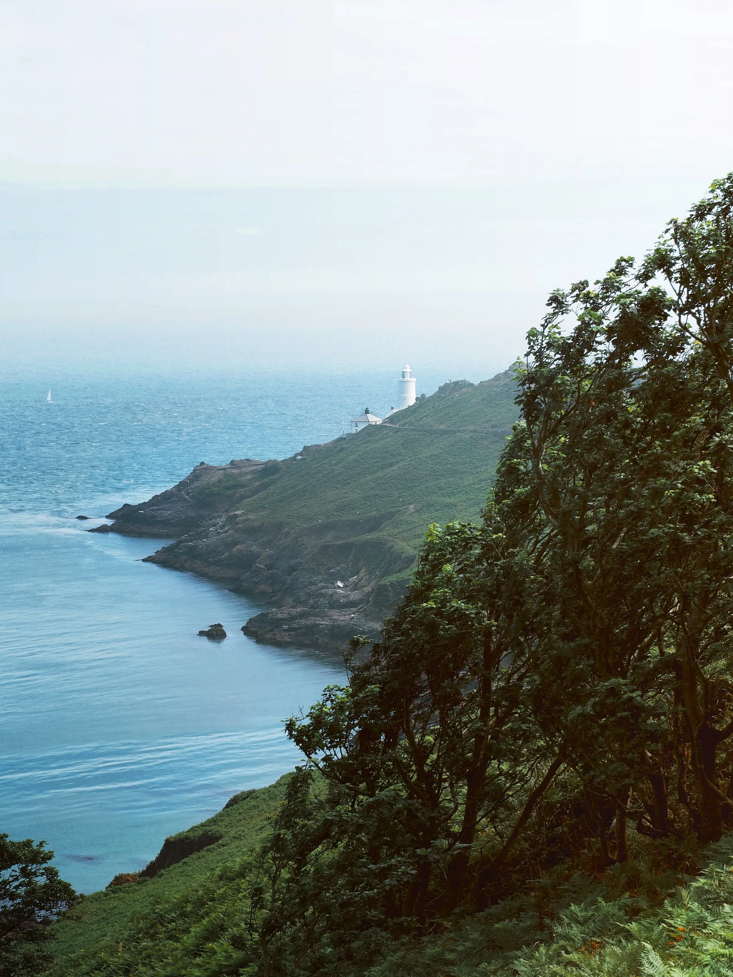
Start Point Lighthouse and Freshwater Bay
Start Point Lighthouse was visible through the summer haze and we pushed on towards it. As the path heading upwards and ever so slightly inland we reached a car park and for the first time in hours we found something that resembled tourism. The coast path continues south away from the lighthouse but we turned east towards Start Point and across the Warren. The Warren was a ridge of greenschist rock which temporally blocked the view of the white tower of the lighthouse. The white lighthouse stood tall and proud above the Shoelodge Reef it was warning ships of. Due to Covid-19 we stopped at some locked gates and we found ourselves unable to explore the grounds of the beacons tower. We sat against the rocks and rested in what little shade we could find during the midday heat.

The K9 Sportsack being put to good use
Our dog had walked the undulating 5km to the lighthouse so we thought it would be best for him, and quicker for us to use his K9 Sportsack for the return journey. With Winston strapped in his carrier, and us aware that the return walk was a retracing of our steps, we began. The walk to Beesands went fairly quickly and before we knew it we were sat outside the Cricketers Inn along the beach drinking a well earned pint of ale along the seafront. From there it was tiresome task of negotiating Dun Point again which was somewhat steeper coming from the south before we were back along the edges of Slapton Leys and had triumphed back to the campsite.
This walk was fantastic and its a superb way to explore South Devon. The South West Coast Path is one of the most used coastal paths in the U.K. and is not only well trodden but also well maintained and you’re never far from a village or some accommodation if you wanted to spread your hike over a weekend or longer.

Start Point Lighthouse